Last month, I went to the shores of S. Nyack, NY to do what I’ve done at least a dozen times before - shoot the moon rising through the towers of the Tappan Zee Bridge. I had a group of people with me - some of whom used either TPE or PhotoPills.
Unlike many previous outings, this time the data was off by about 250-300 yards. The app predicted the moon would rise between the western-most towers of the bridge - but in reality, it rose far more to the west than anticipated. It ruined the shot. The strange thing was that the data from both TPE and PhotoPills both recommended the location we were standing in (on a small dock by a small condo on the shore).
Has anyone else noticed any data discrepancies - specifically around where to stand relative to the moonrise?
Hi @selphotographer - welcome to the forum!
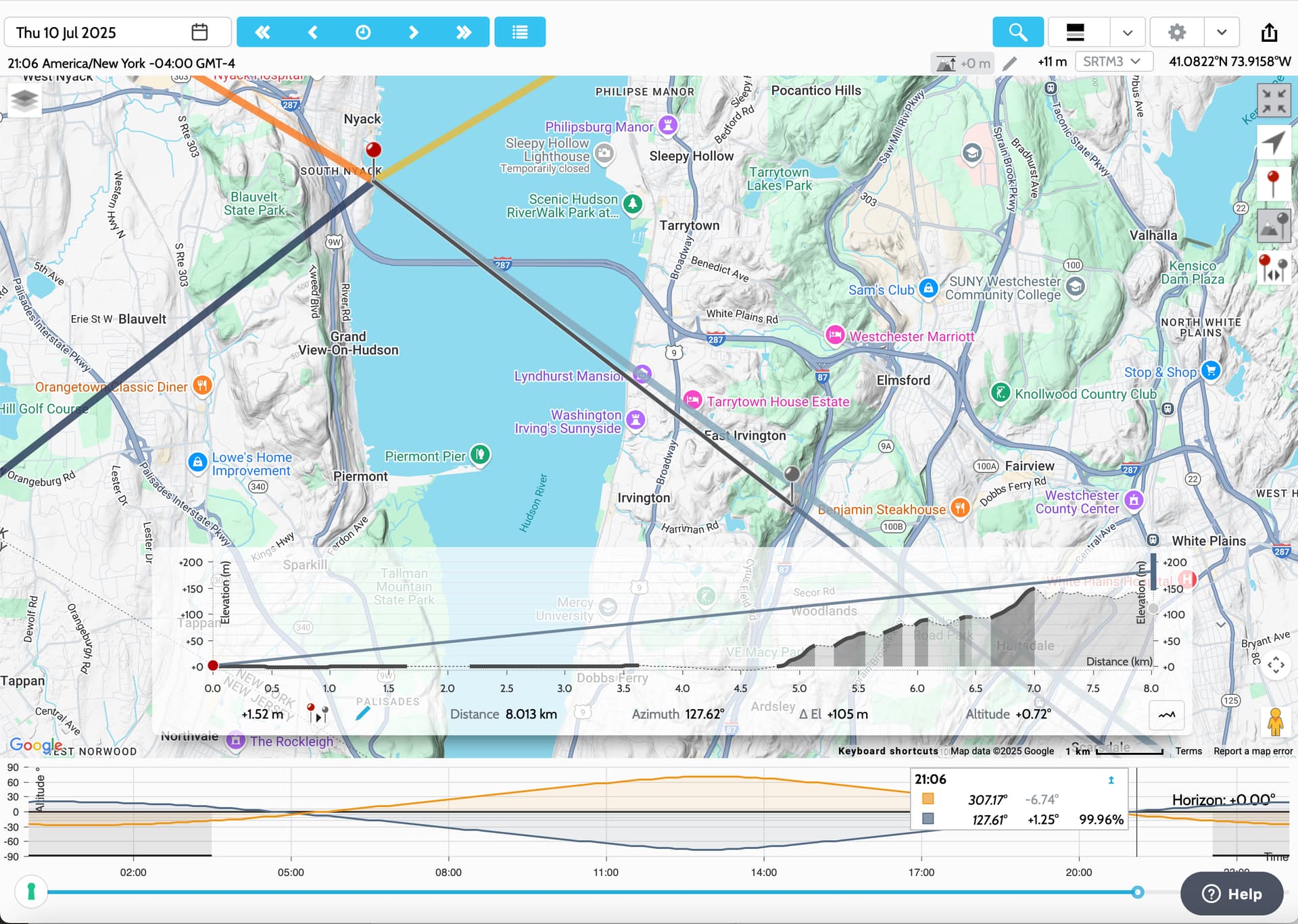
When planning the spot, did you use the geodetics and sightline tools to check the alignment?
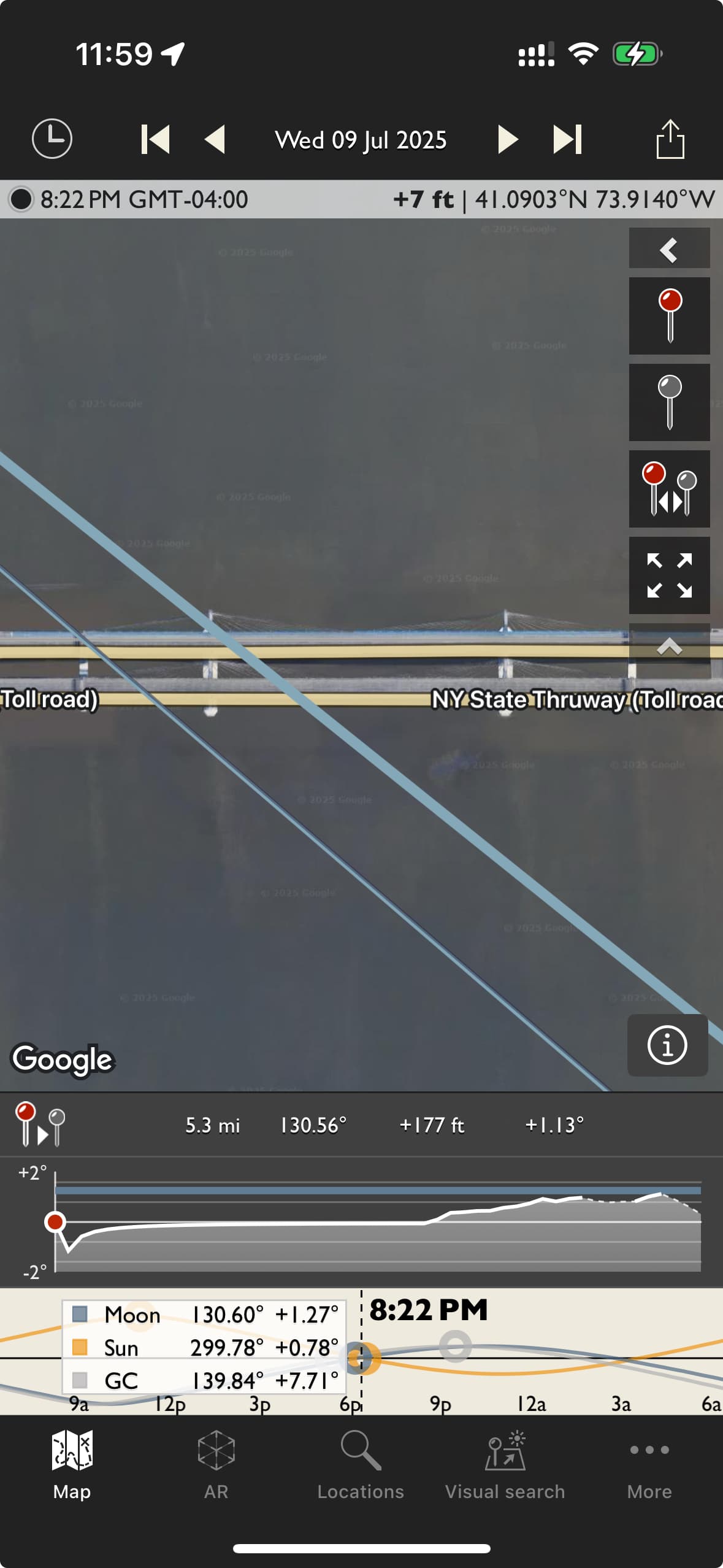
There’s a significant rise in the terrain on the far side of the bridge from your shooting spot that would cause the moon only to become visible a while after official moonrise (12 minutes later), and to appear farther south (i.e. closer to the west end of the bridge) than it otherwise would:
Link
PS. the geodetics and sightline tools are also available in the iOS app:
Hi,
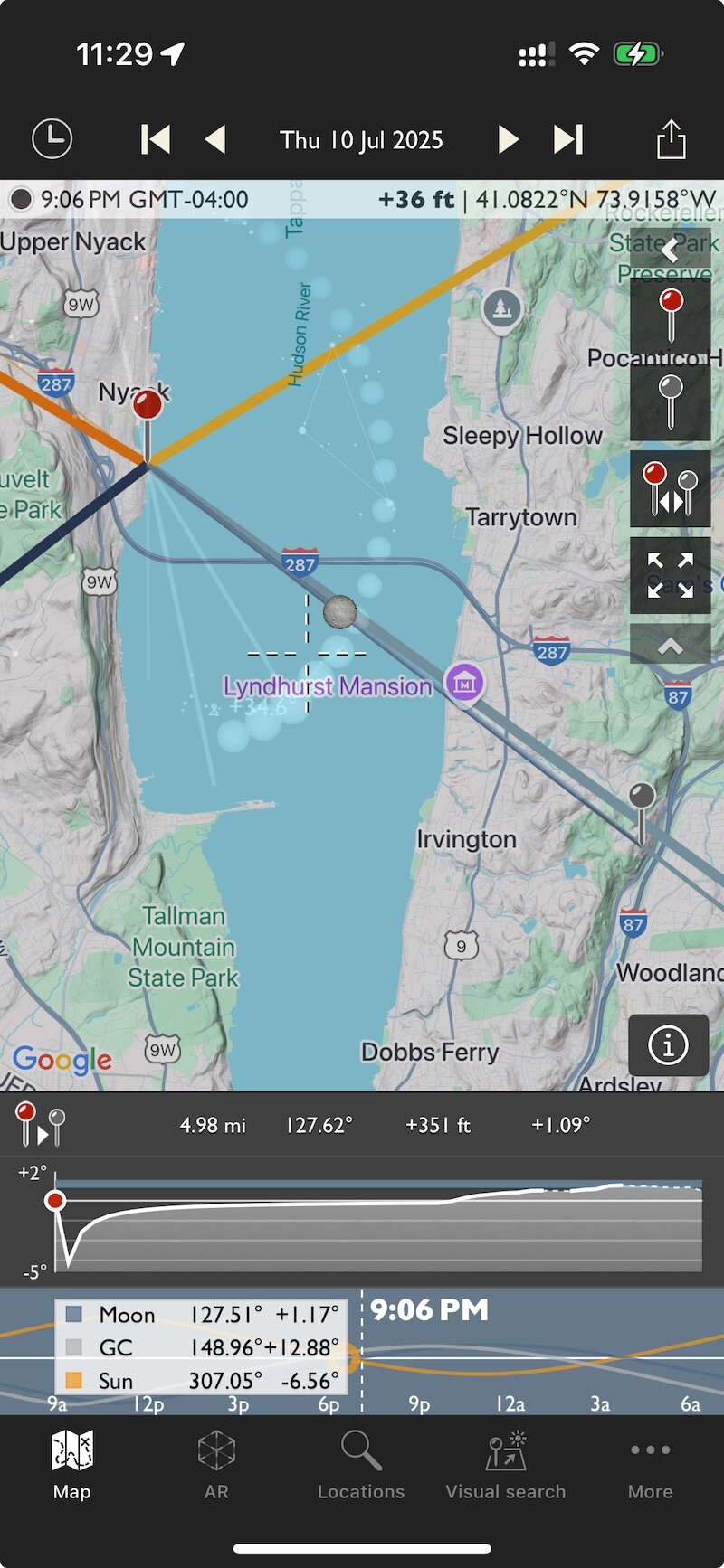
I’ve been using this tool for at least 5 years - and I’ve had awesome results - HOWEVER on this go, here is what I got - vs what I expected. Note the 2 phone screen shots - vs the photo of where the moon actually was as it crossed the hills - and I do know that you need to compensate for the height of the objects behind - the hills - so you don’t see the moon precisely where the moonrise line is - however, look at what I did get. This was what I got:
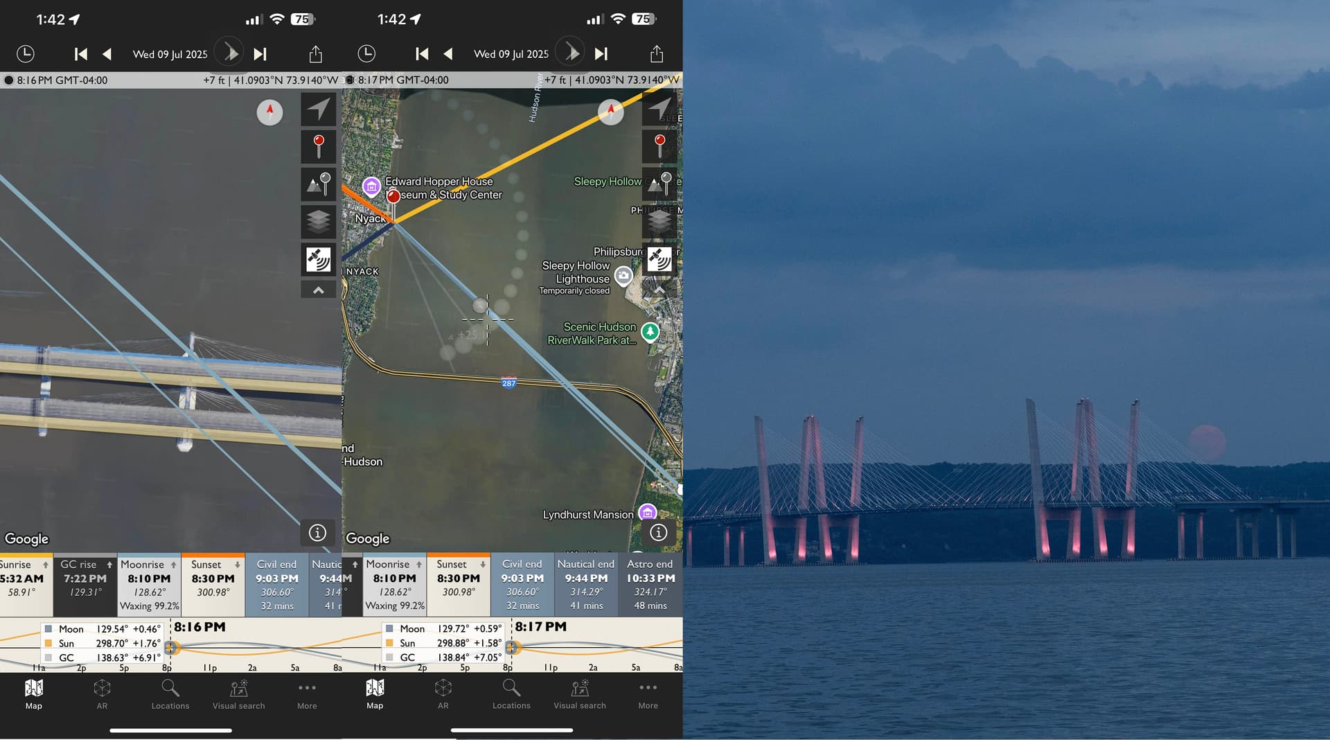
The moon broke over the bridge to the south - at about 14 min past moonrise…
There are 2 shots here that illustrate what we saw.
Note, that I was on a small pier jutting out into the river above the park where the earlier posts were thinking I was… but I was further to the north. And the initial line up looked as 8:10 was moonrise + 12 min = 8:22 - so that should have had the moon nearer to the last strut to the right - the south-most pylon.
Here’s a close up from 8:22:46
Thanks for your reply - and yes, I know about that rise - I know the actual crest over the hills is about 12-13 min after stated moonrise - Please see the images above.
We checked it out in TPE and PhotoPills and there were a few others there who’d done the same thing - and all of us got the same results - it looked as if we should have been roughly 300 yards further NORTH vs where we were (which unfortunately would not have been possible due to private land around there).
Thanks for the screenshots and illustration - I guess the question is, what was it in the app(s) that suggested that your shooting location was the right one? [rephrased for clarity]
From what I can see, it shows exactly what I see in your photo - the moon appearing to the right of the right-hand tower (as viewed from north of the bridge):
I used the coordinates shown in your screenshot and matched up the time to 8:22pm. Maybe I’m misunderstanding something?
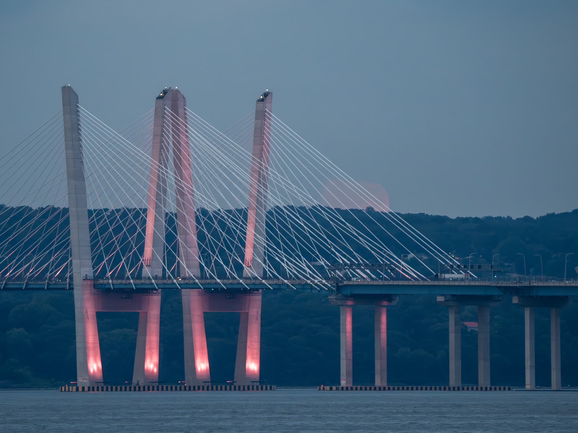
It looked to me like it should have been much closer to the tower - and from the reality of being there - it looked like it was too far to the right. I’ve used this in the past with near-perfect results - and trying to get the moon in the crotch of the cables. This one took me by surprise.
You mean from the appearance on the map? The screenshots you uploaded earlier do show it closer, but that was at 8:16 or 8:17pm before it had crested the ridge. Could that be the issue?
I’d love to understand how I can try to make it clearer - the last thing I want is for anyone to miss a shot.